Advance Ground Scanning in 3D
- Professional: 3D imaging software for OKM metal detectors and 3D ground scanners
- Easy to use: also for less experienced users
- Visualization: of detected anomalies and structures as 2D and 3D graphics
- Determination: of the position, size and depth of hidden objects
- Analysis: of detected objects and structures, including documentation
Visualizer 3D Studio offers treasure hunters, archaeologists and professional users in the industry the possibility to locate and visualize hidden objects in the underground even before excavation. By using the innovative analysis software, the position, size and depth of the detected object can be determined more precisely after the measurement with the OKM detector.
- Software with intuitive operation
- Interactive support by context-sensitive help
- Automatic creation of a three-dimensional representation of the recorded measurement data after importing the raw data from the detector
- Determination of position, size, and depth of the detected objects even before excavation
- Add bookmarks and supplementary notes to specific measurement points
- Automatically compile scan data as a well-structured PDF report
Features:
- 2D Visualization
- 3D Visualization
- 3D Ground scan
- Live sound
- Mineral Scan
- Multilingual operation
- Wireless technology
Upgraded Visualizer 3D in Profesional Edition
- Scan Examples
- Color Schemes - 5
- Selection of Scan Values - Arrow Keys and Mouse
- GUI Designs - 4
- Visualization as Wireframe
- Viewports
- Visualization of Cross Section
- Visualization with Soil Textures
- Soil Types - 12 OKM Standard, 12 USDA , Add and edit individual soil types
- Bookmarks - Can view, add and Edit
- Modifiers - Signal Correction, Interpolation, Subdivision, and Rotational Correction
- Export - Print, Image, and PDF report
Software Features
- Import scan data - Transfer data from the OKM detector or ground scanner via USB cable or Bluetooth and then edit it in the software. Selected detectors (Rover UC, eXp 6000) create the scan file already in .v3d format during the measurement. This can be opened directly with the software.
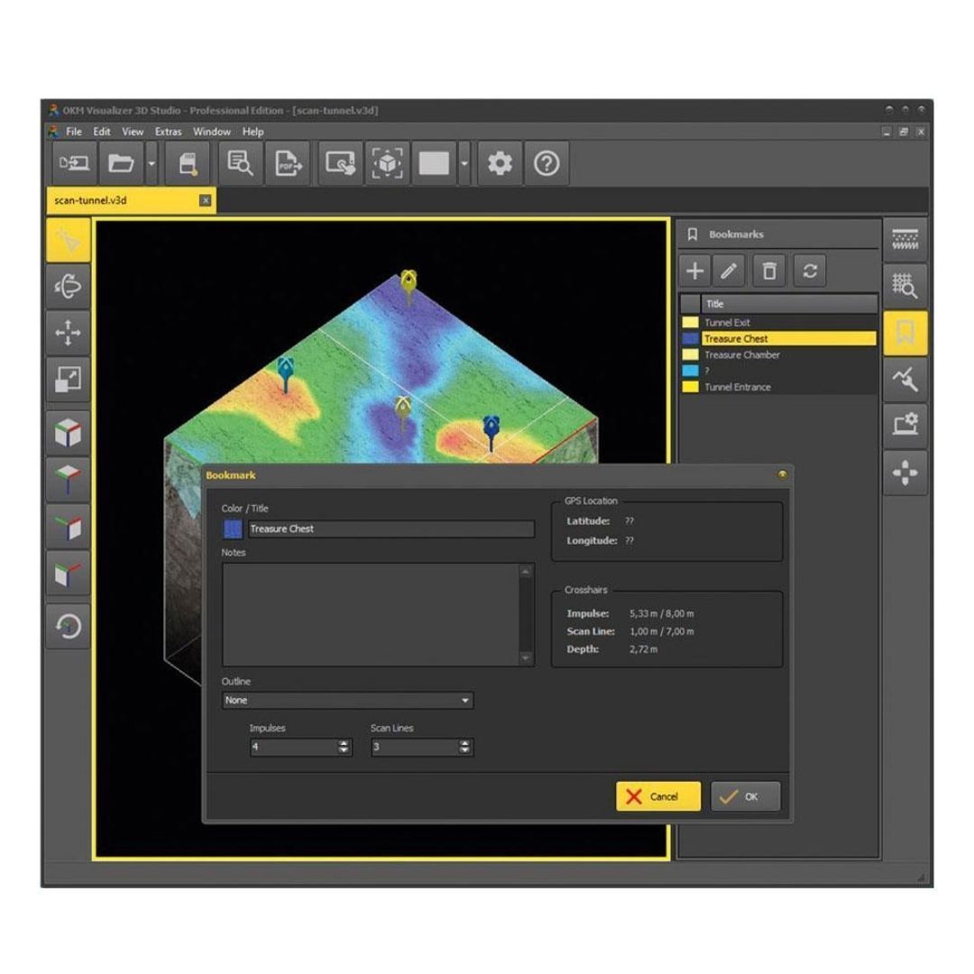
- Edit properties and add notes - In addition to the measured values, basic data such as date, length, and width of the measurement field and (if activated) the associated GPS position are saved for each measurement. This information can be supplemented in the software with further information on the measurement or with information on special measuring field properties.
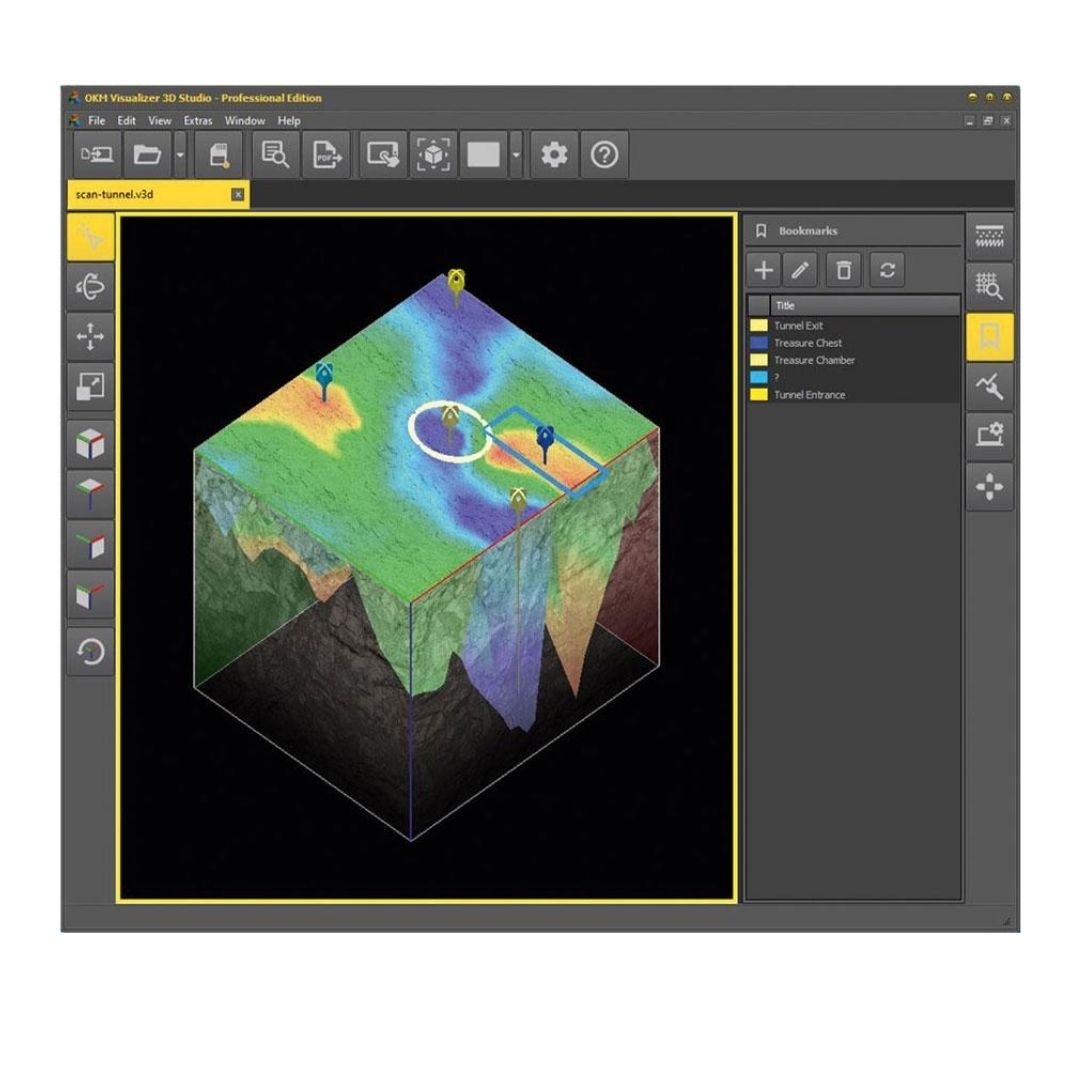
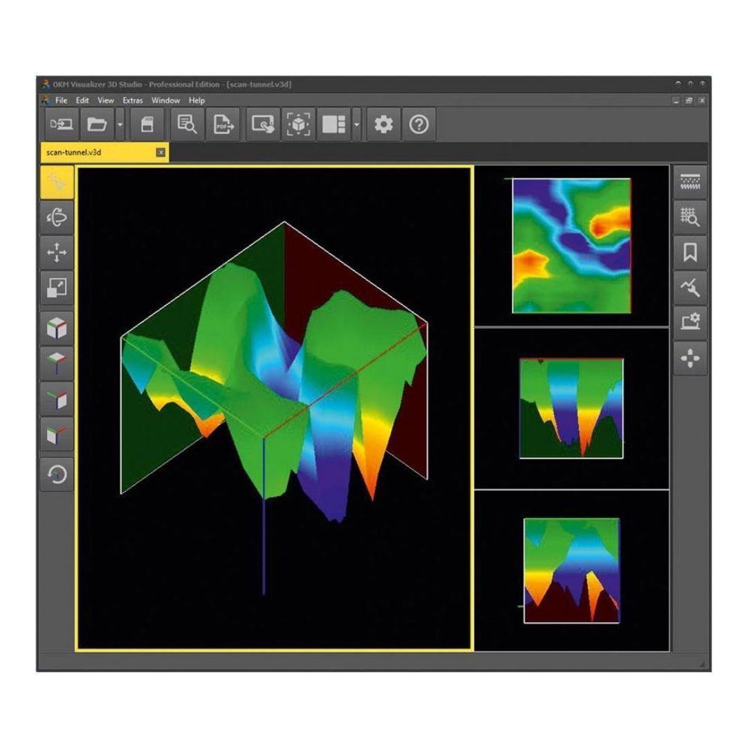
- Adjust views (rotate, scale, move) - The completed scan graphic can be positioned, enlarged, and rotated according to individual requirements. Thus, on the one hand, a top view is possible (2D), on the other hand, three-dimensional views are also possible by rotating. For easy handling, you will find preset standard views to click on in the left toolbar.
- Use predefined viewports- Thanks to preset viewports, the scanned image can be divided among several windows. This means that several perspectives can be viewed at the same time. In order to focus on a specific area, different windows of different sizes can be selected. Alternatively, the display area can be limited to a single window.
- Optimize scan data with modifiers - Using the four predefined modifiers (interpolation, subdivision, signal correction, rotation correction), the measured values are automatically corrected, extended by additional measuring points and recalculated in order to optimize the display and facilitate the search for potential find objects within the measured data.
- Select from various user interface designs - For different ambient light conditions, the software offers four user interface designs to choose from. Select the one that suits your taste!
-
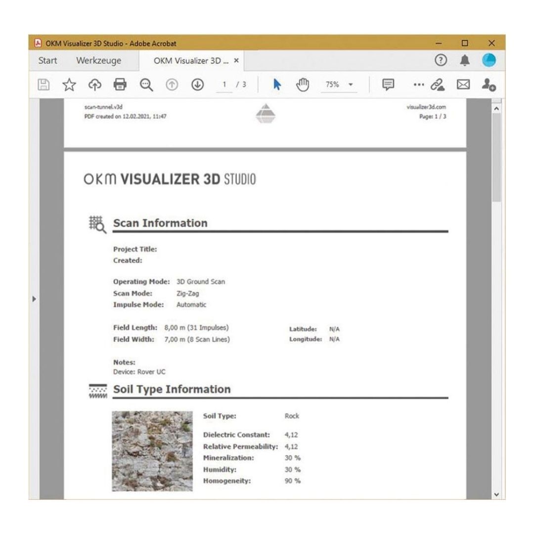
Assign soil types (changes depth calculation and visualization) - With 12 OKM standard soil types and 12 additional USDA soil types, the new Visualizer 3D Studio software offers extended functionality: By selecting the appropriate soil type, the calculation of the depth values is adjusted according to the stored soil properties such as dielectric constant, relative permeability, homogeneity, mineralization, and moisture. The selection of the correct soil type is essential, as the calculation of the measurement depth is significantly influenced by it. For a better visual evaluation, the deposited soil textures can be mapped.
- Select measured values - To select individual scan values, not only the arrow keys but now also the mouse can be used. With this function, details of the selected measured value can be viewed more easily. Furthermore, a bookmark can be set on this point that can be provided with additional information.
- Set bookmarks (PRO only) - Bookmarks can be used to highlight areas of interest and potential findings. A pin on the selected measurement marks a point for which further details can be noted. Optionally, a rectangle or circle can be placed around the point to highlight an entire area.
- Export data as PDF (PRO only) - Until now, the scanned image was only available to be printed directly or exported as an image. This function has been adopted for the Standard Edition and even extended for the Professional Edition: With the PRO version, you can have your scan data automatically compiled. Decide for yourself whether with or without image, scan information, details on soil types, and/or set bookmarks.
- Activate tablet mode - When using the Visualizer 3D Studio software on a tablet or laptop with a smaller screen, it is recommended to activate the tablet mode. This will optimize the display of the import process and improve its visibility.
3D Scan Image Analysis
By using bookmarks, potential finds can be highlighted and labeled directly in the program. This saves the time-consuming processing of scan images in additional programs.
The bookmarks can be saved with the scan file and thus also sent to external viewers (Visualizer 3D Studio software required). The set bookmarks can also be viewed in the Standard Edition. Setting and editing bookmarks are only possible in the Professional Edition.
New Features for Advanced Ground Scan Analyses.
- Benefit from additional visualization options
- Set Individual Bookmarks
- Add Individual Soil Types
- Include Scan Field Photo
- Generate PDF Report
- Additional Preset Soil Types
- Advanced Settings
Easy-to-Use Software - also for Inexperienced Users
Easy-to-understand icons and direct tooltips enable intuitive operation. Sample scans available in the program show users which graphic details may indicate potential targets such as buried treasure chests and artifacts, underground tunnels, burial chambers and underground pipelines.
In addition, users are supported by an interactive help system. This and the online help are currently under construction in English.
The help will be available in further languages soon:
- Deutsch
- Français
- Español
- Polski
- عربى
Use Cases
- Agriculture
- Archaeology
- Cavity Detection
- Explosive Ordnance Disposal Services
- Forensics
- Geotechnical Engineering
- Militaria Detection
- Natural Gold Prospection
- Public Services
- Treasure Hunting
- OKM Search Services
Supported Metal Detectors and Ground Scanners
The scan analysis software Visualizer 3D Studio has been specially designed for OKM metal detectors and ground scanners.
Compatible Products: Evolution NTX, eXp 4500, eXp 6000, Fusion Light, Fusion Professional, Fusion Professional Plus, Ground Navigator 2.0, Rover C4, Rover UC
Moreover, the various editions of the ground scan analysis software - Visualizer 3D Standard and Professional - are also compatible with these previous detectors:
Previous Products (Data Transfer): Future 2018, Evolution, Rover C - New Edition, Rover C II - New Edition, Rover Gold, Rover Deluxe - New Edition, Future I-160, GEMS, eXp 4000, eXp 5000, Ground Navigator
In addition, all saved measurements in .v3d format such as 3D Ground Scan and Mineral Scan, which were performed with older OKM ground scanners and metal detectors, can also be opened in the new Visualizer 3D Studio software. This allows to view, edit and analyze the scan data with the new software, which offers new functions and tools.
Watch Video Here!
How to pay with Bitcoin
How to pay with Crypto
Shop Gift Cards
Top 10 Best Selling Metal Detectors
Buy Metal Detectors
Buy Gold Detectors
Buy Gold Prospecting Gear











 PRODUCT DESCRIPTION
