Groundtech A2 GEO Ground Scanner
Groundtech
- Regular price
- Price: $4,250.00
- Regular price
- List Price:
- Sale price
- Price: $4,250.00
- Unit price
- per
SKU:
Couldn't load pickup availability
Share
This Deal Ends In:
 PRODUCT DESCRIPTION
3D Ground Scanner with Geo-Electric Detection
The A2-GEO Model is equipped with a Geo-Electric system. This system allows you to detect groundwater sources, underground tunnels, ancient tombs, and caves from much deeper levels. It enables quick scanning across four lines with both manual and automatic scanning systems, and results can be analyzed in 3D on the Groundtech Suite application.
Features
- 6 Scanning Features
- 3D Scanning
- Multi Language Support
- Dual Sensor Technology
- Geo-Electric System
-
Search Depth: Up to 20 meter
-
Warranty: 2 Year Warranty
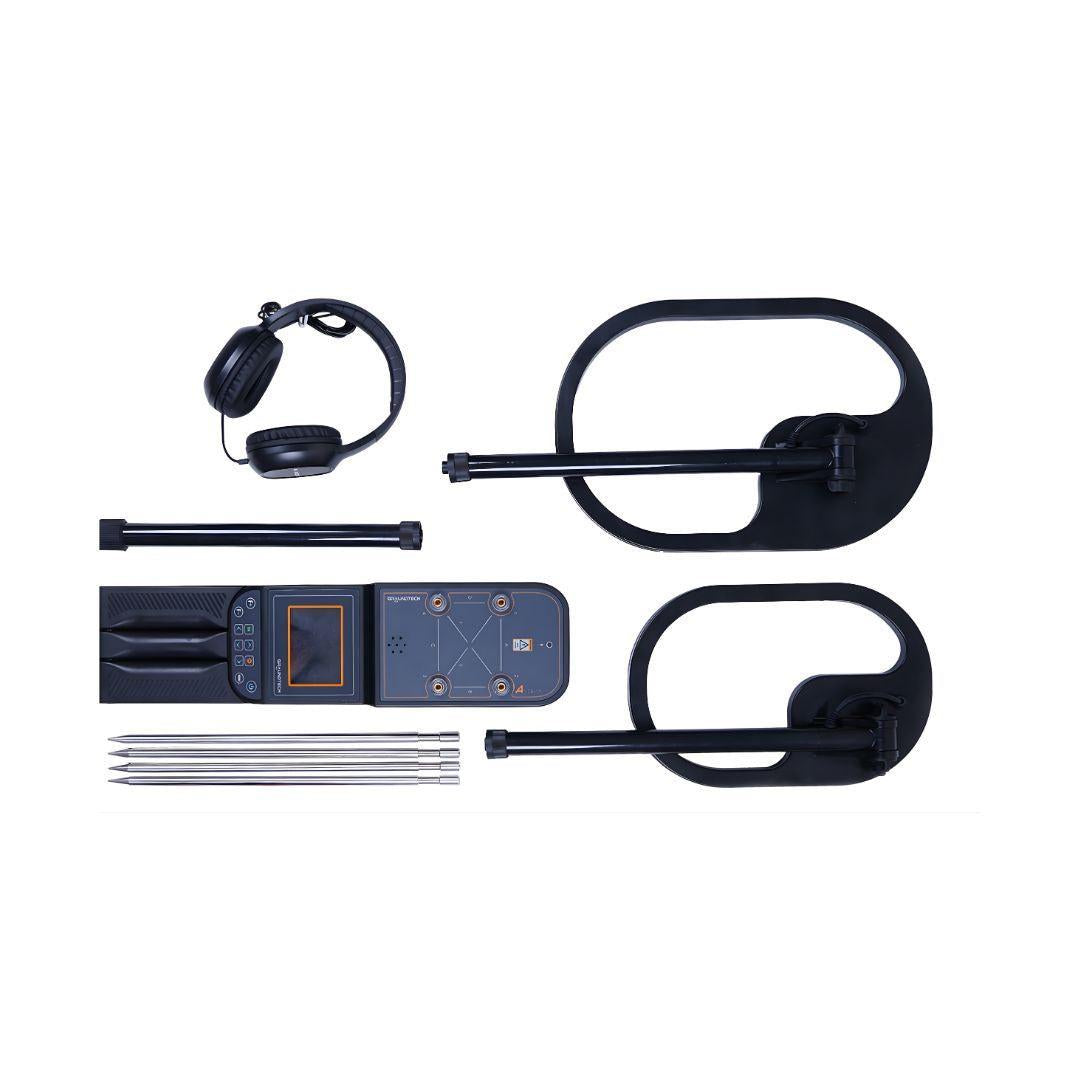
Package Contents
- Main Unit
- PiD25 Detector Search Coil
- PiD30 detector Search Coil
- MFS-3 Dual Sensor
- Charging adapter
- 4 Conductive Probes
- 4 x 25 Meters conductor cable
- Headset
- User manual
- Carrying bag
Geo-Electric Detection Technology
The Groundtech A2 Geo features an advanced Geo-Electric (resistivity) detection system designed to analyze soil conductivity and resistance below the surface. This technology allows the device to detect non-metallic targets such as voids, tunnels, caves, groundwater, and buried structures—targets that traditional metal detectors cannot identify.
Next-Generation Ground Scanning
The A2 Model is an advanced ground scanning detector that allows you to detect underground anomalies and perform 3D analysis. Designed as a practical and versatile metal detector and 3D ground scanner, the A2 Model offers integrated and multi-functional solutions for professional treasure hunters, archaeological treasure seekers, and the discovery of underground structures. The device is equipped with six different scanning modes.
Perfect MFS-3 Dual Sensor Technology
High-sensitivity MFS-3 Dual Sensor technology allows you to carry out more sensitive and deeper scanning. This advanced sensor technology, which minimizes the margin of error, ensures you get perfect scanning results. Combined with a faster processor, the A2 GEO model provides an enhanced and precise exploration experience.
3D Graphics
While scanning with the A2 Model, settings and results are displayed to the user on the integrated screen of the device. It also provides real-time detailed and 3D analysis through the G-Portal (Groundtech Portal) application, specifically developed for Android and iOS devices.
How deep would you like to go?
You can carry out scanning up to a 20 meter depth depending on the soil structure and the size of objects. Get results far beyond those achievable by standard detectors.
** Variable depending on the soil structure and the size of buried objects as well as the scanning function.
Different Scanning Features
- 3D Ground Scanning System
- Detector Quick Scan System
- Pinpointer Function
- Live Scanning Function
- Detector Advanced Scan Mode
- 3D Ground Scanning Detector Mode (Standard Scanning)
- Resistivity Automatic Scanning
- Resistivity Manual Scanning
Multi-Language Support
- English
- German
- Spanish
- Italian
- French
- Turkish
- Russian
- Chinese
- Arabic
- Persian
Technical Specifications:
| System | 3D Ground scanner and integrated pulse induction metal detector |
| Sensor Technology |
MFS-3 Dual Sensor Technology (Gradiometer) ± 3000 µT |
| Detector Technology |
Pulse Induction Technology – 1 kHz frequency |
| CPU | 240 MHz CPU - 12-bit A/D converter |
| Resistivity System | 100v – 66mA output, 62 Hz, 50 sample interval |
| Depth | 3D Scanning system up to 20 meters deep |
| 3D Analysis Application | G-Portal Android & iOS 3D Analysis program |
| Language | Device 11 languages, Mobile App 25 languages |
| Battery | 3.7 V Li-ion rechargeable battery |
| Operating Time | Up to 10 hours. |
| Wireless Connection | Bluetooth 4.2 BLE |
| Operating Temperature | 0°C - 70°C |
| Storage Conditions | -20°C - 60°C |
| Charging Input Voltage | Type-c 25w charger adapter |